Jump to content

Drought & Heat Adaptation Using Sensors & Data

LORIOT Verso Drought & Heat Adaptation

Drought & Heat Adaptation
Using Sensors & Data

Droughts last longer and heatwaves hit harder. Reacting is no longer enough. Our IoT solution turns hyper-local soil, plant and climate data into early warnings and precise irrigation decisions.

Water is becoming the scarcest resource in agriculture, forestry and municipal green management, and the decisions around it are rarely simple. Irrigation schedules follow the calendar rather than the crop, restrictions are declared for entire regions regardless of local conditions, and the real stress a plant is under only becomes visible once the damage is already done.

With our solution we enable the transition from calendar-based irrigation and blanket water restrictions towards a measured, real-time and field-level understanding of drought and heat stress. Every litre is allocated where it creates the most value, and every restriction can be justified with data instead of estimates.

Benefits


Early warning

Early
Warning

Heat and drought stress build up long before leaves wilt. By tracking soil, air and plant indicators continuously, the system flags deteriorating conditions days ahead and triggers preventative action while it is still cheap and effective.
Water usage

Optimized
Water Usage

Irrigation is driven by what the roots actually need. The system helps to prevent over-watering and drainage losses, stretching the available reserves so that more water remains in storage when the dry period arrives.
Decision-making

Objective
Decision-Making

Our system provides verifiable metrics that replace guesswork with objective data. Water allocation, irrigation bans and compensation decisions rest on measurements that all stakeholders can see and trust.

How it works?
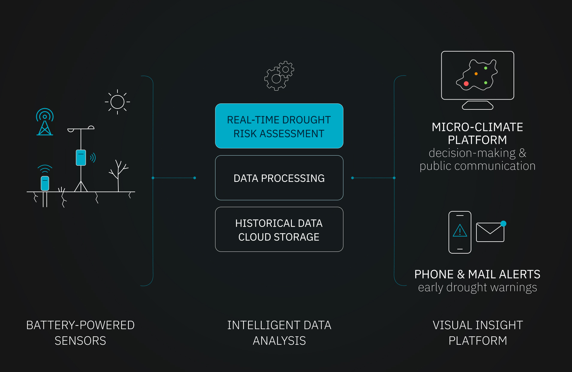

  1. SENSOR MEASUREMENT

    To accurately monitor drought and heat stress, a multi-layered sensor set is deployed directly on-site:

    – Soil moisture probes measure volumetric water content and electrical conductivity at varying root depths to track exactly how much water is available, and at which layer.
    – Temperature and humidity sensors monitor localized microclimates and calculate important indices like the vapor pressure deficit (VPD) to predict extreme stress before it becomes visible.
    – Dendrometers track the water retention within tree trunks to measure actual biological stress rather than an estimate of it.
    – Weather stations record hyper-local rainfall accumulation, wind speed and solar radiation to establish reliable field baselines.
  2. REAL-TIME ANALYSIS

    Thanks to highly energy-efficient and long-range wireless technology, all sensor data is transmitted in real time to the cloud, including from remote fields, parks and forest plots without power or mobile coverage.

    This raw data is processed through our intelligent platform, where integrated algorithms clean the incoming data points, structure the information across depth layers and locations, and calculate the indicators that matter for your organization, from VPD and water balance to depletion rates per soil horizon.
  3. INSIGHTS, ALERTS & INTELLIGENT IRRIGATION

    The results are made available in a digital dashboard that links every measurement to a specific plot, zone or area, with historical trends and forecasts alongside the live readings.

    Furthermore, the system generates SMS, email or third-party notifications when conditions surpass defined danger limits, for example soil moisture below 20% or temperatures exceeding 45°C, so the right person is informed at the moment action is still possible.

    Additionally, it combines all analyzed data points to optimize irrigation, applying water only where and when the root zone requires it. This maximizes the value of every litre used and preserves as much of the available reserve as possible for the drought periods ahead.
Drought & Heat Adaptation Infrastructure Graphic


Book a Free Call

FAQ


  • How many sensors do I need for my land or territory?
    Every project is different, and the number of necessary sensors varies depending on soil type, topography, crop or vegetation, and local climate. To be as cost-efficient as possible, sensors are placed at strategic, representative locations to cover as much area as possible. From a technological perspective there is no restriction on the minimum or maximum area that can be covered.
  • At which depths are the soil probes installed?
    Depths are chosen according to the root profile of the vegetation being monitored, typically spanning the surface layer down to the lower root zone and, where relevant, below it. Measuring several layers at once is what makes it possible to distinguish a brief surface wetting from a genuine recharge of the root zone.
  • What is VPD (Vapor Pressure Deficit)?
    VPD expresses how strongly the atmosphere is pulling moisture out of a plant, combining temperature and relative humidity into a single figure. It is a far better predictor of heat stress than temperature alone: a hot but humid day and a hot, dry, windy day place completely different demands on the same crop. Tracking VPD allows stress to be anticipated instead of observed after the fact.
  • Is cellular network coverage required in the field?
    No. Our solution is technology independent, and hybrid deployments combining technologies such as LoRaWAN® (independent of mobile coverage) and 5G are possible. This allows data acquisition from remote areas and valleys where conventional connectivity is unavailable.
  • How long do the sensor batteries last?
    Depending on transmission frequency, most field sensors operate for several years on a single battery. Our intelligent system also monitors battery health and notifies you well in advance when a replacement is needed.
  • Can the solution be integrated with existing systems?
    Yes. Integration with farm management systems, smart city or other platforms is no problem and can be adapted to your needs.
  • Who owns the data?
    You do. Whether the customer is a public authority, a cooperative or a private grower, data control and the resulting analytics always remain with the organization that commissioned the system.
  • What is the typical timeframe for end-to-end implementation?
    Our extensive global network enables us to set up your system quickly and smoothly. Smaller projects can be running in just a few weeks. Bigger projects can take a little longer, due to the increased communication and organization effort across the various stakeholders involved.
  • How much does the solution cost?
    The solution is adaptable to various budgets and project sizes. A single-farm pilot is just as feasible as a region-wide rollout. Pricing varies accordingly.
  • How does the technology behind the solution work?
    If you want to learn more about the technological aspects of our solutions, please read here.


Interested in protecting your crops, forests or green spaces from drought and heat?


Let’s discuss how we can tailor this drought and heat adaptation system to your specific project.